| Ecosystem |
North Sea |
| Type |
Sea/Bay/Gulf |
| Salinity |
saltwater |
| Other Names |
|
| Location |
|
LME SAU No 22. Northeast Atlantic, from eastern Channel to Skagerak, Kattegat, north to Stavanger and Shetland Isles. LME2002, Modified LME 2006, SAU 2008. |
62° N 50° N - 5° W 12° E |
|
| Location Map |
North_Sea.png |
| Size Ref |
|
River Length |
|
Area |
695749 km2 |
Drainage Area |
|
|
| Depth |
|
Average Depth |
|
Max Depth |
|
Ref |
|
|
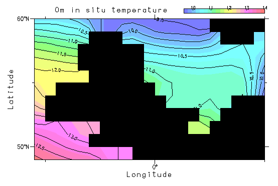
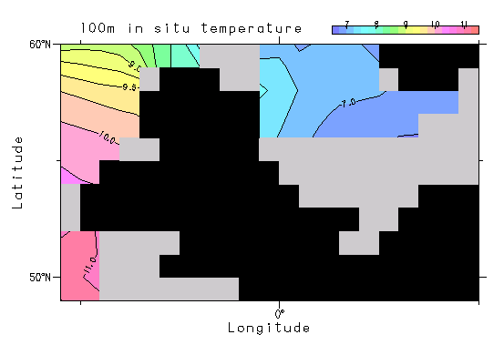
| Temperature |
|
| Description |
The North Sea (including the Channel out to 5° W and part of the Kattegat) covers an area of 745,950 km² with a volume of about 94,000 km³. The greater part of the sea is shallower than 200 m, but is bordered by a deep trench down to 700 m off the coast of Norway. A former glacial moraine forms a shallow bank that divides the summer stratified northern North Sea from the largely tidally mixed shallow southern North Sea. The greater part of the bottom is covered in sand and gravel (due to glaciation). The coast shows great variability from the deltaic protected coastline at the mouth of the Rhine, to sand dunes to massive cliffs in the north. Currents driven by tides and winds dominate the circulation which is guided by the topography. Inflow of Atlantic water occurs along the edge of the Norwegian trench at approximately 100m and is overlain at the surface by outflow of low saline water from the Baltic (http://www.na.nmfs.gov/lme/text/lme22.htm) |
| Comments on faunal list |
Area from SAU (November 2015). |
| URL 1 |
http://www.seaaroundus.org/lme/22.aspx |
| URL 2 |
|
| Ecosystem Checklist Link |
|
| Total |
|
Species |
Families |
Species |
Families |
Reference |
|
3186 |
892 |
|
|
35388 |
|
