| Ecosystem |
Insular Pacific-Hawaiian |
| Type |
Sea/Bay/Gulf |
| Salinity |
saltwater |
| Other Names |
|
| Location |
|
LME SAU No 10. From Kure Island to Hawaii. LME2002, LME2006, SAU 2008. |
30° N 18° N - 179° W 152° W |
|
| Location Map |
Insular_Pacific-Hawaiian.png |
| Size Ref |
|
River Length |
|
Area |
980517 km2 |
Drainage Area |
|
|
| Depth |
|
Average Depth |
|
Max Depth |
|
Ref |
|
|
| Temperature |
|
| Description |
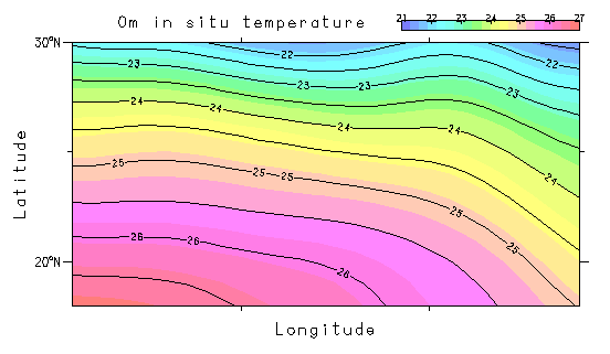
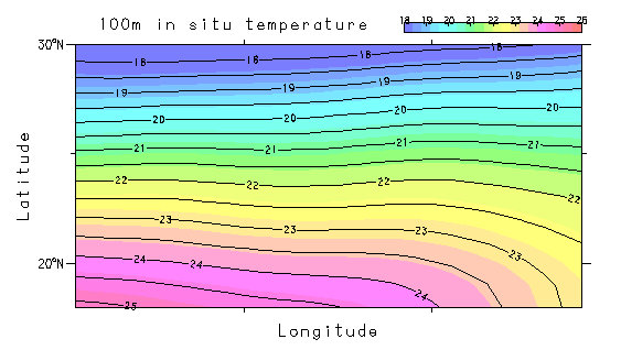
The Insular Pacific-Hawaiian Large Marine Ecosystem is the marine region surrounding the Hawaiian Islands. It was formed during the last few million years by successive periods of volcanic activity over the Hawaiian hot spot, interspersed with submergence, weathering, and fluctuating sea levels. Cool ocean currents and persistent northeasterly trade winds provide the islands with a subtropical climate. Ocean temperatures, ranging from 21 degrees C to 29 degrees C, are lower than in other areas of similar latitude. The islands are surrounded by coral reefs and contain numerous bays. For more information on environmental conditions influencing the island chain (climate, temperature, salinity, waves, currents and tides), see the Ocean Atlas of Hawaii. The LME is influenced by currents coming from the western North Pacific and from the North Pacific equatorial area. Read the Ocean Atlas of Hawaii for more on environmental conditions influencing the island chain (http://na.nefsc.noaa.gov/lme/text/lme10.htm). |
| Comments on faunal list |
Area from SAU (November 2015). |
| URL 1 |
http://www.seaaroundus.org/lme/10.aspx |
| URL 2 |
|
| Ecosystem Checklist Link |
|
| Total |
|
Species |
Families |
Species |
Families |
Reference |
|
146 |
96 |
|
|
|
|
